Famous Mountain
Daedeoksan Mountain (Keundeoksan Mountain)
Inquiry
Yongyeon Cave Management Office 033)550-2727
Location
283-29,Taebaek-ro, Taebaek-si (Hwajeon-dong)
Introduction
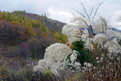
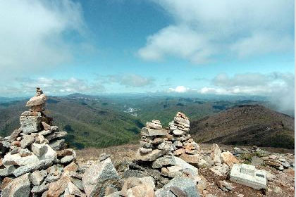
Daedeoksan Mountain with the elevation of 1,307m is located to the northernmost of Taebaek and the flat soils begin from Geumdaebong Peak to the north.
There is natural grassland of reeds instead of trees on the top of the mountain, and the legend says that there used to be the Sajikdan Altar built by the Yusin of Goryeo.
It is called as Keundeoksan Mountain or Daedeoksan Mountain in Chinese letters because the top of the mountain is flat and reaches hundreds of thousands of square meters. It is known for having Bihaksangcheonhyeong (a crane flying over a mountain) in the mountain where flying squirrels, onychodactylus fisheri, and rare plants like Leontice microrhyncha S. Moore, Anagallidium dichotomum, and megaleranthis saniculifolia ohwi inhabit. Large grassland of hundreds of square meters extends over the top of the mountain, which reminds of a golf course. It is a good tourist spot along with the riverhead of the Hangang River.
Maebongsan Mountain
Inquiry
Taebaek Tourist Information Center: 033)550-2828 / 552-8363
Location
Samsu-dong, Taebaek-si
Introduction
Cheonuibong Peak with the elevation of 1,303m is the source of the Nakdonggang River and the Namhangang River, and is called Maebongsan Mountain. Cheonuibong Peak, meaning a sky peak, forms the junction of the Taebaek Mountain Range and Sobaek Mountain Range.
The range reaching down from Baekdusan Mountain forms Geumgangsan Mountain, Seoraksan Mountain, Odaesan Mountain, and Dutasan Mountain. And it continues to the south to Cheonuibong Peak and splits into two ranges. The western range continues to Geumdaebong Peak, Hambaeksan Mountain, and Taekbaeksan Mountain and becomes Sobaeksan Mountain Range. It even reaches Jirisan Mountain and the end of the Haenam Peninsula. This range once again leads to Gujibong Peak of Gimhae along the southern coast of Korea. The eastern range continues to Baekbyeongsan Mountain, Myeonsan Mountain, and Ilwolsan Mountain. And it becomes the ridge of Taebaeksan Mountain Range that reaches Yongdusan Mountain in Busan. This mountain is indeed the junction point of the Taebaeksan Mountain Range and Sobaeksan Mountain Range.
Cheonuibong Peak is also called Maebong Peak because there is a small pond to the bottom and an old tomb to the top of the site in which Hwangji-dong Daemyeong mining station existed. Cheonuibong Peak looks like a hawk (Mae in Korean) when viewed from this tomb of Yeonil Jeong Clan, which is called Geumgyeporan. Geumgyeporan means a propitious site for a grave as if a hen is sitting on an egg. According to feng shui, a hawk or a vulture must be staring at this site and that is why Cheonuibong Peak is artificially called as Maebong Peak. It was supposed to be Maebong but as people began to call it Maebongsan Mountain, having a double meaning. It’s just like calling Yeokjeon (in front of the station) as Yeokjeonap (in front of Yeokjeon).
It is recorded as Maemakbong Peak(鷹幕峰) in Jinjuji, and some say that people used to enjoy hawking here.
Baekbyeongsan Mountain
Inquiry
Taebaek Tourist Information Center: 033)550-2828 / 552-8363
Location
Hwangyeon-dong, Taebaek-si (Tong-dong)
Introduction
It is the highest mountain among the mountains of the Nakdong Ridgeline that split off from the Baekdudaegan Mountain with the elevation of 1,259m.
The Nakdong Ridgeline begins from Samsuryeong Pass (Pijae Pass) and reaches to Dadaepo in Busan. It consists of rock cliffs at the top unlike Geumdaebong Peak which is composed of flat soils.
It is called Baekbyeongsan Mountain because the mountain looks like it is surrounded by a rock screen. According to the legend, Byeongpungbawi Rock is white when there is a drought and black when it rains. Thus, people judged whether there would be a drought or it would rain by looking at the color of this rock. On the summit, there is a stone marker of triangulation in the size of around 10m2 to 13.2m² at the top.
The highlight of this mountain is Byeongpungbawi Rock but it is also famous for Chotdaebawi Rock and Magohalmibawi Rock. When you stand on Ambong Peak (Byeongpungbawi Rock), you can glance through Taebaek and the most complex geographical structure of the Baekdudaegan Mountain that wraps around Taebaek.
Yeonhwasan Mountain
Inquiry
Taebaek Tourist Information Center: 033)550-2828 / 552-8363
Location
Dongjeom-dong, Taebaek-si
Introduction
Yeonhwasan Mountain with the elevation of 1,171m is located in the middle of Taebaek, and it is no exaggeration to say Taebaek is formed around this mountain like a finger ring. There is Yeondangji Pond in a shape of lotus floating on water and it is called Yeonhwasan Mountain because the shape of the mountain looks like a lotus. It used to be called Yeonhwabong Peak in the past, but it is called Yeonghwasan Mountain these days.
In particular, it surely looks like a lotus when viewed from Mungok Station.
There are Oknyeobong Peak and Tugubong Peak, which are the highest peaks, in Yeonhwasan Mountain.
From the summit of Yeonghwasan Mountain, you can take in a grand view of Taebaek. There are many attractions such as Yeonhwasan Recreation Area, Chunghontap Tower, and Yeonhwa Falls at the entrance of the trail.
Hambaeksan Mountain
Inquiry
Taebaek Tourist Information Center: 033)550-2828 / 552-8363
Location
Hwangji-dong, Taebaek-si
Introduction
Over the ridge on the summit of Hambaeksan Mountain that leads to the north, there are habitats of yew and dead tree as well as many medicinal herbs like bupleurum falcatum.
According to the Samguk yusa (Memorabilia of the Three Kingdoms), Hambaeksan Mountain is recorded as Myogosan Mountain which has the same meaning as Sumisan Mountain. It was considered a sacred mountain and had many temples including Bonjeokam Hermitage, Simjeokam Hermitage, Myojeokam Hermitage, and Eunjeokam Hermitage.
More than 1,300 years ago, Monk Jajang Yulsa found Galbanji site according to the revelation of the Bodhisattva of wisdom and drove away a big Korean rat snake. He built the Jeokmyeolbogung (Shrine for Sakyamuni Buddha's Sarira) and Sumanotap Pagoda to enshrine Sari (small crystals sometimes found among cremated remains of monks, and regarded as sacred relics) of Buddha there. The yew tree besides the Jeokmyeolbogung is called Seonjangdan Altar because people believed that the cane planted by Monk Jajang Yulsa revived. Furthermore, Geungnakgyo Bridge and Jeongamsa Valley are famous as habitat for manchurian trout, which is Natural Monument 73.